Updated: June 13, 2024
Background
Many of our South Carolina Airports were developed in the 1930s and 1940s. Though initially rather secluded and rural, this is often no longer the case. In the ensuing years, development of all types has often surrounded our Airports. They have also undergone significant physical changes over time in an effort to improve safety, efficiency, and compatibility with surrounding development.

Airports are impacted by three-dimensional concerns as well as airspace imaginary surface penetrations that may occur off of the Airport property. Also, certain types of development are more compatible than others with Airport operations. Finally, the trapezoidal-shaped approach surfaces on either end of the Runway are especially critical, because they are above the area where aircraft are transitioning from air to ground or ground to air.
For these reasons, as well as quality-of-life concerns such as aircraft noise and exhaust, development in areas that are in close proximity to an Airport should be more closely scrutinized than other areas in the City or County may be. This webpage will provide basic information for the Developer, Architect, Planner, and Engineer regarding development projects that are being considered near a South Carolina Airport.
American Planning Association
“Airport compatible land uses are defined as those uses that can coexist with a nearby airport without either constraining the safe and efficient operation of the airport or exposing people living or working nearby to unacceptable levels of noise or hazards.”
FAA Form 7460-1, Obstruction Evaluation & Airspace Analysis
This is a Standard Form that is published by the FAA and entitled NOTICE OF PROPOSED CONSTRUCTION OR ALTERATION. Its purpose is to:
Evaluate the effect of the construction or alteration on aircraft operating procedures;
Determine the potential hazardous effect of the proposed construction on air navigation;
Identify mitigating measures to enhance safe air navigation;
Place new objects on Navigational Charts.
A link to this form is provided at the bottom of this page. Check with your local government planning officials early in the development process; submission of this form is often a legal requirement.
Additionally, when construction is imminent, there is a second form, Form 7460-2 (NOTICE OF ACTUAL CONSTRUCTION OR ALTERATION) that may be required as well.
CLUE Tool Background
The Compatible Land Use Evaluation (CLUE) Tool is an online, computer-based model provided by The South Carolina Aeronautics Commission (SCAC) that enables developers to locate their proposed development on the map to find out if it is in an Airport Safety Zone or an Airport Land Use Zone.
Title 55, Section 55-13-5 of the South Carolina State Code of Laws requires that certain development applications in SCAC-specified Airport Safety Zones and Airport Land Use Zones be submitted by local government planning, zoning, and building permit officials to SCAC for review and comment. This interactive site is designed to assist the general public in understanding airspace and land use compatibility near airports by evaluating a "test case" development proposal against Federal Aviation Administration (FAA) and SCAC standards.
CLUE Tool Analysis and Findings
Application of the CLUE Tool will determine compatibility of the proposed rezoning or development based on the following criteria:
(Height) Airspace penetrations / obstructions to air navigation
Wildlife attractant
Land Use
Environmental (Hazardous Materials)
Findings, by each criterion will be:
Compatible
Conditional
Incompatible
CLUE Tool and local development regulations
There may be differences between the standards of the model zoning and development ordinance used in CLUE Tool analyses and the actual zoning and development regulations in place in the locality throughout the State. Remember:
The CLUE Tool reflects development “Best Practices” that will ensure the safety and viability of the Airport and people on the ground; but
The local zoning and development ordinance and / or Airport Overlay District are the minimum standards that govern development decisions by local permitting officials.
So, what if there is a conflict between these two standards?
The SCAC Staff will advise all parties (the developer, the permitting jurisdiction officials, and the Airport Sponsor) on the results of the CLUE Tool analysis.
The SCAC Staff will make recommendations based on the CLUE Tool analysis results in order to ensure that maximum appropriate level of safety is afforded to those souls on the ground as well as those souls in the air and that the viability of public capital investment in the Airport is not undermined.
Ultimately, decisions regarding what development to permit or not, are that of the local permitting officials (who may or may not also be employed by the sponsor, or owner, of the Airport). If, however, CLUE Tool Analysis finding recommendations are not reflected in local decisions / approvals, the permitting agency must explain their decision, by condition and in writing, to the South Carolina Aeronautics Commission. The Commission may further challenge the approval in Court if they believe that there is significant cause to do so.
Jurisdiction
It is not uncommon that stakeholders in the process of near-Airport development could be multi-jurisdictional (Map of Affected Jurisdictions ). For example, the Airport could be owned and operated by a County Government, but the off-Airport area under consideration for development could be located within the boundaries of a City or Town.
These Governments will hopefully have Airport Overlay District (AOD) ordinances and an accompanying map that protects the Airspace Imaginary Surfaces surrounding the Airport from temporary (trees or cranes) or permanent (buildings, towers, poles) penetrations. In some cases, these ordinances will also address compatible land use.
The Airport Compatible Land Use Workflow
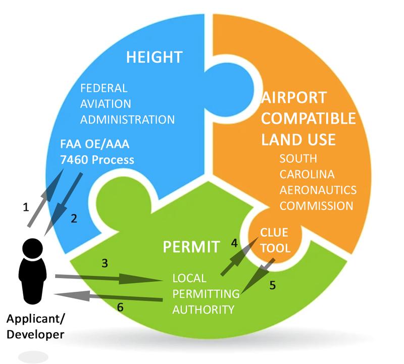
The Applicant / Developer submits FAA Form 7460-1 to the Obstacle Evaluation / Airport Airspace Analysis (OE/AAA) site online at: https://oeaaa.faa.gov/oeaaa/external/portal.jsp
The Applicant / Developer receives the airspace study finding to determine height compatibility. Please note that the FAA analysis only reviews project impacts on airspace; a “no hazard” finding does not necessarily mean that the project is compatible with the Airport and its operations.
The Applicant / Developer provides the FAA airspace finding results to the Local Permitting Authority Official (LPO) and requests an airport Compatible Land Use Evaluation (CLUE) case be submitted on their behalf.
The LPO submits the CLUE Tool case to South Carolina Aeronautics Commission (SCAC) Staff for analysis.
The SCAC Staff analyzes the CLUE Tool case and issues a finding as: “Compatible”, or “Conditional”, or “Incompatible” with regard to Airport land use compatibility.
The LPO approves or denies project development permits with consideration of SCAC CLUE findings.
Definitions
Airport Overlay District (AOD) – A district described on the zoning map within which, through superimposition of a special designation, further regulations and requirements apply in addition to those of the underlying districts to which such designation is added. The airport overlay district is established in recognition of airport related hazards which may endanger lives and property; obstructions which effectively reduce airspace required for aircraft takeoff, landing, and maneuvering which reduce the utility of an Airport and the public investment therein.
(Airspace) Imaginary Surfaces – There are five types of imaginary (can be defined, but cannot be physically seen) surfaces which the Federal Aviation Administration (FAA) has applied to public use airports for the purpose of determining obstructions to air navigation.
They exist to prevent existing or proposed manmade objects, objects of natural growth or terrain from extending upward into navigable airspace.
These imaginary surfaces either slope out and up from all sides and ends of runways or are a horizontal plane or a sloping plain above public use airports. They are defined as:
Primary Surface: Aligned (longitudinally) with each runway and extends 200 feet from each runway end;
Horizontal Surface: Horizontal plane 150 feet above the established airport elevation. Constructed by swinging arcs around the end of the primary surface;
Conical Surface: 20:1 slope surface extending beyond the horizontal surface;
Transitional Surface: Constructed to join approach and horizontal or approach and transitional surfaces;
Approach Surface: Longitudinally centered with the runway and extends beyond the primary surface.
These imaginary surfaces are more completely described in 14 CFR (Code of Federal Regulations), Part 77 and are frequently referred to as “Part 77 Airspace” (see definition below).
CLUE Tool Approach Zones
Zone A - The Runway Protection Zone (RPZ) which the FAA defines as, “An area at ground level prior to the threshold or beyond the runway end to enhance the safety and protection of people and property on the ground.”
Zone B1 - The inner approach zone. An area where aircraft operate on approach or departure from an airport. Dimensions vary with runway classification.
Zone B2 - The outer approach zone which is an extension of Zone B1, inner approach zone. An area where aircraft operate on approach or departure from an airport. Dimensions vary with runway classification.
Aircraft Approach – The airborne directions, path, conditions, and navigational aids that an aircraft follows in transitioning from air to ground at its destination airport.
Obstruction Light – A light indicating the presence of an object which is dangerous to an aircraft in flight.
Noise Contour – A line on a map that represents equal levels of noise exposure. The Airport uses the FAA computer model, the Integrated Noise Model (INM), to calculate noise contours based on the current aircraft fleet mix. The number of annual flights, aircraft types, flight tracks, runway use and time of day are critical inputs to the noise contour model. The unit plotted on the map is the Day / Night Noise Level (DNL) in 5-decibel increments for DNL values of 60, 65, 70, 75 and 80. The FAA defines significant noise exposure as an area within the annual 65 DNL noise contour. Federal guidelines, adopted for appropriate land use planning, identify incompatible residential land use within an annual average noise exposure of 65 DNL or higher.
(Airspace) Elevation Contour
Runway Protection Zone (RPZ) – A trapezoidal shaped area off the end of the runway end that serves to enhance the protection of people and property on the ground in the event an aircraft lands or crashes beyond the runway end. RPZs underlie a portion of the approach closest to the airport.
(14 CFR) Part 77 Airspace –That section of the Code of Federal Regulations, having the force of law, that ensures the Safe, Efficient Use and Preservation of the Navigable Airspace. It specifically defines Airspace Imaginary Surfaces that surround the Airport and must be protected and preserved.
Title 55 – The South Carolina State Law pertaining to Aeronautics.
Obstruction Evaluation / Airport Airspace Analysis (OE/AAA) – That evaluation and analysis performed by the Federal Aviation Administration (FAA) Staff of proposed development that may impact Airspace Imaginary Surfaces near the Airport. Initiated by the submission of the FAA Form 7460-1.
Noise Abatement – Voluntary procedures followed by pilots in maneuvering aircraft in close proximity to the Airport to help mitigate the effects of aircraft noise to those on the ground.
(Airspace) Obstacle / Penetration – Any object that penetrates clearance requirements within 14 CFR Part 77 protected surfaces.
(Airspace) Obstruction – Any obstacle that impacts navigable airspace.
South Carolina Aeronautics Commission (SCAC) – That State Agency that coordinates Aeronautical matters on behalf of the State Government to include the preservation, development, and improvement of State public-use Airports.
Exhibits:
Noise Contour Exhibit
Model Compatible Land Use Ordinance
14 CFR Part 77 Airspace Diagrams
Useful Website Links: